
|
|||||||||
| Dursley - where is it? | |||||
|
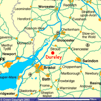
The market town of Dursley is located in the county of Gloucestershire in the southwest of England, approximately 12 miles south of Gloucester, 25 miles north of Bristol and 100 miles west of London. It is easily accessible from all directions, being situated close to the M4 and M5 motorways. |
|||||
 |
There are five main access routes to the town centre, these being:
|
||||
| Image produced from Ordnance Survey Get-a-map service. Reproduced with permission of Ordnance Survey and Ordnance Survey of Northern Ireland. | |||||
| The first of these routes approaches the town from the top of the Cotswolds before descending the steep Whiteway Hill into Woodmancote Road and arriving at the Market House via Silver Street. The second route takes traffic off the A38 trunk road into Cam and makes its way through Cam High Street, Cam Pitch, Tilsdown and into Kingshill Road. This is joined by the third and fourth routes close to the site of the police station. The last route into Dursley is perhaps the most scenic - it ascends from Stroud via Selsley common, along the edge of the Cotswold escarpment and then drops down into Uley via the steep Crawley Hill and into town along the Uley Road. | |||||