| |
Picture Gallery (Click
on picture for larger view) |
 |
 |
 |
| |
 |
|
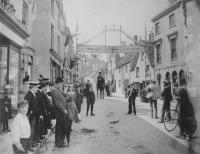
Celebrations
in the town centre
Large smartly dressed crowds gather to cheer the Dursley contingent
of the Royal Gloucestershire Hussars through the town centre. Some
of the shops visible in this view include Carr
(Grocer) on the left, Walters and Son (Bakers) and the Post Office.
(c1905 - courtesy Cam & Dursley Camera Club) |
|
 |
| |
 |
|
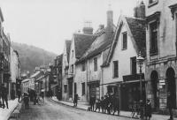
Parsonage
Street before the Great War
The boys in uniform are from the private school on Bull Pitch. Also
visible are the Kings Head Inn and
the old Post Office on the right, now demolished.
(c1910 - courtesy Cam & Dursley Camera Club) |
|
 |
| |
 |
|
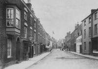
Dursley
telephone exchange
Visible in this view looking towards the Market House are the Hillview
Public Telephone Office on the left and the old telephone exchange.
Further down the street is the shop of Alfred Hucker (Tailor). The
telephone exchange was demolished to make way for the current junction
with Castle Street.
(1907 - courtesy Cam & Dursley Camera Club) |
|
 |
| |
 |
|
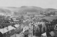
View
from the church tower
With Stinchcombe Hill in the background, this photo shows the extent
of Parsonage Street looking west. In the foreground can be seen the
roofs of the now demolished buildings that once hid the church from
view. Also visible are the Market House and the old Police Station,
right centre.
(c1910 - courtesy Cam & Dursley Camera Club) |
|
 |
| |
 |
|
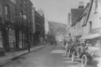
Signs
of things to come
Changes are afoot and the modern world starts to encroach in this
view which sees early cars parked along Parsonage Street.
(c1920s - courtesy Cam & Dursley Camera Club) |
|
 |
| |
 |
|
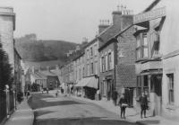
Entrance
to Castle Farm
To the right of this picture can be seen the narrow entrance to Castle
Farm beyond the Bell and castle Hotel.
Barclays Bank now (2003) occupies the hotel site and the alleyway
has been widened as a pedestrian walkthrough.
(c1914
- courtesy Cam & Dursley Camera Club) |
|
 |
| |
 |
|
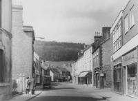
No
more farms in the town centre
Contrast this with the previous picture - the small outbuilding on
the right has gone and Barclays Bank stands where the hotel once stood.
On the far right is "The Toy Box" toy shop.
(April 20th 1969 - courtesy Cam & Dursley Camera
Club) |
|
 |
| |
 |
|
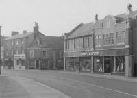
May
Lane junction
The Cooperative Stores stands at the entrance to May Lane (on the
site now occupied by the Warehouse). On the opposite corner is the
Coop confectionery shop, then the shops of H.
Pegler & Son (butcher) and Selby
Robinson (florists).
(1959 - courtesy Cam &
Dursley Camera Club) |
|
 |
| |
 |
|
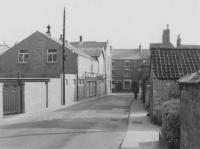
May
Lane looking towards Parsonage Street
This view along May Lane shows the junction with Parsonage Street
in the distance. At this time Castle Street had not been built and
the building visible opposite the T junction is the old telephone
exchange which was later demolished.
(1959 - courtesy Cam & Dursley Camera Club) |
|
 |
| |
 |
|
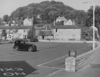
Hill
Road car park
Looking little different from the scene today (2003), excepting the
car, this view shows the car park situated on Hill Road, Dursley.
A row of cottages, "Hardings Row", sometimes called "Pig
Face Row" was demolished to make way for its construction.
(c1959 - courtesy Cam & Dursley Camera Club) |
|
 |
| |
 |
|
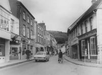
View
from the Market House
Modern times approach in this view from the Market House. Shops that
can be seen include Walters (cakes), Hewitt, Boots
(chemist), Baileys (news), Eastmans (butcher), Miss Cope (chemist)
and Burtons (grocery).
(1969 - courtesy Cam & Dursley Camera Club) |
|
 |
| |
 |
|
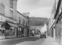
View
west along Parsonage Street
Shops visible in this view west include Burtons
(grocery), Durcans (hardware) and G.A.Pugh and Son (The Bargain Centre,
hardware).
(April 20th 1969 - courtesy Cam & Dursley Camera
Club) |
|
 |
| |
 |
|
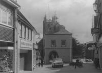
The
Market House, Parsonage Street
Looking east towards the Market House, Daniels Television shop and
the Stroud & Swindon Building Society can be seen on the left.
(1988 - courtesy Cam & Dursley Camera Club) |
|
 |
 |


